Piko
Piko Promptu incele ↗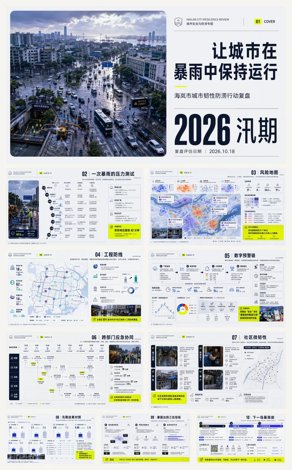
ChatGPT
TasarımChatGPT
International style documentary city resilience report ppt
Üretici @xiaoxiaodong01
Prompt
Build a report-type PPT that juxtaposes large-scale documentary photography with clear information architecture, with the internationalist layout system as the main axis: use modular grids and baseline grids to lock column widths, margins, title and body rhythms; use Gestalt law of proximity and common areas to cluster content into scannable blocks; use editorial rhythm to create tension and relaxation between main visual pages, white-space information pages, and multi-column data pages. Borrow Josef Müller-Brockmann's asymmetric mathematical grid to govern alignment, Alexey Brodovitch's radical cropping, image scale, and white space to create narrative pauses, Massimo Vignelli's limited fonts and unified components to maintain consistency throughout the set, and Josef Albers' adjacent color field relationships to calibrate the recognition of chapter color tabs and information cards, with each method managing one domain without mechanical imitation. Establish replaceable color roles: main visual field accounts for 55%—70%, medium-dark values, medium-high saturation, and retaining natural light and dark levels; paper background accounts for 20%—35%, high brightness, low saturation; structural text accounts for 8%—15%, ensuring clear projection with extreme light-dark contrast; chapter coding and key prompts together account for 3%—8%, using multiple groups of equally-weighted high-purity colors to produce temperature and saturation jumps between adjacent modules. Future themes or brand colors are mapped item by item according to main visual, background, text, coding, and prompts, replaced once while maintaining area proportions, brightness sequences, chromaticity differences, adjacency relationships, and contrast intensity. Pages run on asymmetric multi-column grids: theme pages let high-angle top-down documentary photography become the main quality, placed within large rounded corner boundaries, forming three-stage reading with small logos, theme titles, and oversized time information; content pages combine column text, equal-height cards, and edge-aligned narrow chapter color tabs in wide outer margins, allowing a single title or photograph to break across columns; the bottom edge of the information card is gathered with a single-pointing folded corner, the first reading is the title or focal image, the second reading is the summary, and the third reading is the details. Photography uses real ambient light, subtle grains, and brightness compression from near to far, performing natural tone correction first, then cropping with rounded corner masks, retaining edge details and local highlights; information pages use textureless matte backgrounds, overlaying low-transparency outline numbers, single-line geometric icons, and thin color bars, synthesized in the order of background, image or card, structural lines, text, and coding. Adopt coordinated pairings of same-skeleton geometric sans-serifs: display characters are oversized, bold-narrow, tightly tracked, and can cross columns, partially turning into hollow outlines, forming character-image overlapping with photography; the body text uses regular weight and higher line spacing, and the caption text is smaller but with wider letter spacing. Chinese and English font sizes are aligned by optical blackness rather than nominal size, correcting optical margins for numbers, full-width punctuation, and rounded boundaries, and the body text avoids complex images. The overall presentation is credible, clear, pragmatic, open, organic, and action-oriented.

——————
Theme: Review of Hailan City's Urban Resilience and Flood Prevention Actions
A total of 10 pages
Aspect ratio 16:9
Content logic:
01|Cover: Keeping the city running during heavy rain—lock the 2026 flood season review theme and assessment date with high-angle top-down documentary images of the urban area after the rain.
02|A heavy rain stress test: restore precipitation peaks, water accumulation diffusion, traffic disruption, and disposal response hour by hour, establishing a temporal causal chain of problem occurrences.
03|Risk Map: overlay low-lying areas, population density, critical facilities, and drainage capacity, identifying five types of high-risk units and their priority judgment basis.
04|Engineering Defense Line: present the coverage and capacity improvement of pump station expansion, pipeline network repair, storage space, and sponge facilities, distinguishing between completed, under construction, and gaps to be filled.
05|Digital Early Warning Chain: explain how meteorological monitoring, model forecasting, graded early warning, and grassroots reach are connected, and verify system effectiveness with lead time and arrival rate.
06|Cross-departmental Emergency Coordination: show task handovers, time consumption, and bottlenecks among urban management, transportation, fire protection, sub-districts, and public utilities through a real disposal process.
07|Community Micro-resilience: focus on four scenarios: underground spaces, elderly living alone, schools, and merchants, explaining the coverage effects of community plans, material points, and volunteer networks.
08|Flood Season Result Comparison: compare this year with historical rainfall of the same level, presenting the number of water accumulation points, water recession duration, suspension time, and loss changes, avoiding only reporting inputs.
09|Three Exposed Shortcomings: clarify old pipeline network blind spots, early warning terminal breakpoints, and insufficient nighttime coordination, providing evidence, impact scope, and rectification priorities respectively.
10|Before the Next Heavy Rain: form an action roadmap for 90-day repairs, annual expansion, and three-year system upgrades, implementing responsible departments, completion standards, and public inquiry portals.
Layout strategy: Use storm blue-purple as the main visual, cold grey-white background, and fluorescent yellow prompt colors to create a high-alert contrast, structural text is near-black; the cover lets a large rounded-corner aerial view on the left run through the top and bottom, with oversized time and short titles stacked on the right, inner pages use diagonal event trajectories, unequal narrow and wide double columns, partial cross-column risk maps, and full-page conclusion rotations, titles are right-aligned and preceded by numbers, time review is compact, risk explanation has white space, and the action list increases density again.
Metni kopyala, kendi detaylarını ekle ve kullandığın görsel modelinde dene.